Introduction
Every country has a geographical extent, but the lines separating states represent far more than divisions on a map. International borders determine where governments exercise territorial authority, how people travel between countries, where customs duties apply, and which state is responsible for enforcing its laws. They can support peaceful cooperation, yet they can also become sources of political tension, economic disruption, and armed conflict.
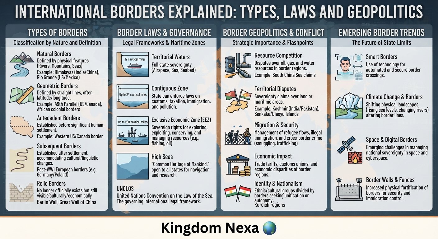
International borders explained means understanding how boundaries are established, legally recognized, physically marked, administered, and sometimes disputed. Some follow rivers and mountain ranges, while others are based on historical agreements, colonial-era decisions, diplomatic negotiations, or judicial rulings. Maritime boundaries add another dimension by determining rights over coastal waters, fisheries, seabed resources, and offshore energy reserves.
In today’s interconnected world, borders influence international trade, migration, national security, environmental protection, and regional integration. Their significance is especially clear when neighboring countries disagree over territory or when governments strengthen border controls in response to security concerns.
This guide explains the meaning and major types of international borders, their historical development, the legal principles governing them, and their strategic importance. It also examines real-world examples, modern border-management technologies, unresolved disputes, and possible future developments in international boundary politics.
What Are International Borders?
An international border is a legally recognized or claimed boundary separating the territorial jurisdiction of two states or distinguishing a state’s territory from areas outside its national jurisdiction.
Borders define the geographical limits within which a government normally exercises sovereign authority. They help determine the application of national laws, immigration rules, taxation systems, customs regulations, policing powers, and other public responsibilities.
However, a border is not always a universally agreed line. Neighboring states may disagree about its location, the interpretation of an old treaty, or ownership of a particular territory. A boundary can also be legally established but incompletely marked or difficult to control on the ground.
The Difference Between a Border and a Boundary
The terms border and boundary are often used interchangeably, but they can carry slightly different meanings.
A boundary usually refers to the precise legal or geographical line separating territories. A border can refer to that line and the broader area surrounding it, including checkpoints, border communities, roads, customs facilities, and security infrastructure.
For example, the boundary between two countries may follow a surveyed line across a remote desert. The surrounding border region may contain settlements, trade routes, military posts, and regulated crossing points.
This distinction matters because agreeing on a boundary does not automatically resolve every practical issue associated with managing the border.
Why International Borders Matter
International borders perform several interconnected functions:
- Political: Define the territorial scope of state authority.
- Legal: Help determine which country’s laws and courts have jurisdiction.
- Economic: Govern customs procedures, tariffs, trade inspections, and cross-border transport.
- Security: Provide a framework for immigration enforcement, policing, and military planning.
- Social: Influence citizenship, family connections, migration, and cultural exchange.
- Environmental: Help states coordinate the management of shared rivers, forests, wildlife, and ecosystems.
Borders are therefore both geographical divisions and institutions that shape relations between governments and populations.
How Did International Borders Develop?
Modern borders developed through centuries of territorial expansion, warfare, diplomacy, state formation, and legal agreements. Their evolution reflects changing ideas about sovereignty, political authority, and national identity.
Early Territorial Divisions
Ancient political communities often controlled territory through fortified settlements, military outposts, tribute systems, and zones of influence. Their boundaries could be flexible rather than precisely surveyed.
Natural features such as rivers, deserts, and mountain ranges frequently influenced territorial control. However, these features did not always form permanent or uncontested boundaries.
As administrative systems developed, rulers increasingly relied on written agreements, land records, maps, and officials to define territorial limits.
The Development of the Modern State System
The Peace of Westphalia of 1648 is commonly associated with the historical development of the modern European state system. Nevertheless, modern sovereignty emerged gradually, and the treaties did not instantly create today’s international order.
Over subsequent centuries, centralized governments expanded their administrative reach, mapped territory more precisely, and negotiated boundaries with neighboring powers.
The spread of European colonialism also transformed global borders. Colonial administrations frequently drew boundaries that divided existing communities or combined different populations within new political units. Some of these lines later became international borders following independence.
Decolonization and New International Boundaries
The twentieth century brought major changes to the global political map. The dissolution of empires, the independence of Asian and African states, and the breakup of multinational states produced new international boundaries.
In some cases, newly independent countries retained inherited administrative boundaries to reduce uncertainty and limit competing territorial claims. The principle known as uti possidetis juris has played an important role in certain decolonization and state-succession contexts, although its application depends on the relevant legal circumstances.
Partition, population displacement, contested territorial claims, and the division of communities have also made some borders politically sensitive long after their formal establishment.
Major Historical Turning Points
| Period | Significance |
|---|---|
| 1648 | The Peace of Westphalia became an important reference point in the development of the European state system. |
| Nineteenth century | Nationalism, imperial expansion, surveying, and diplomacy reshaped many territorial boundaries. |
| 1945 onward | The United Nations Charter strengthened the international framework for sovereignty and peaceful dispute settlement. |
| 1945–1970s | Decolonization created many new states and international boundaries. |
| 1991 onward | The dissolution of the Soviet Union and Yugoslavia generated new states and numerous boundary and status questions. |
| Twenty-first century | Digital mapping, migration pressures, security concerns, and climate change have added new dimensions to border management. |
These developments demonstrate that international borders are historical products rather than simply natural divisions that have existed unchanged for centuries.
What Are the Main Types of International Borders?
International borders can be classified according to their physical characteristics, historical origins, and legal status. The following categories explain the most important distinctions.
Natural Borders
Natural borders follow geographical features such as mountains, rivers, lakes, and deserts.
Mountain ranges can provide recognizable reference points, although difficult terrain may complicate surveying and access. Rivers can support transport and agriculture, but shifting channels may create disagreements about the precise boundary.
A river boundary may follow one bank, a defined coordinate line, or the main navigable channel, depending on the relevant treaty and applicable law. There is no universal rule that every international river boundary follows the deepest channel.
Natural features can make boundaries easier to identify, but they do not eliminate disputes.
Geometric and Artificial Borders
Geometric borders follow straight lines or specified coordinates rather than prominent physical features.
Some boundaries use parallels of latitude, meridians of longitude, or lines established through surveying. They are especially common in regions where historical agreements or administrative decisions produced geometrically defined borders.
Such boundaries may be straightforward to describe mathematically. However, the communities living around them may have long-standing economic, cultural, or family connections that do not correspond to the line.
Antecedent, Subsequent, and Superimposed Borders
Political geographers also classify borders according to their historical development.
Antecedent borders were established before substantial settlement or before the main cultural landscape developed in an area.
Subsequent borders emerged after populations and cultural patterns had developed. They may reflect negotiations, political change, or attempts to accommodate existing communities.
Superimposed borders were imposed by external powers without fully accounting for local political, ethnic, linguistic, or social patterns. Certain colonial-era boundaries illustrate this category.
These classifications are analytical tools, not automatic judgments about whether a boundary is legally valid.
Land Borders and Maritime Boundaries
Land borders separate territories across land, while maritime boundaries define the limits of coastal states’ maritime zones and, where applicable, their jurisdiction over seabed resources.
Maritime boundaries are particularly important because neighboring states may claim overlapping areas of sea. Disagreements can affect fishing rights, offshore oil and gas projects, naval operations, shipping routes, and undersea infrastructure.
International law treats maritime zones differently from land territory. A country’s exclusive economic zone, for example, does not give it the same sovereignty over the entire water column that it exercises over its land territory.
How Are International Borders Established?
Establishing a border usually involves legal, diplomatic, geographical, and technical processes. A boundary may take years to negotiate and implement, particularly where terrain is difficult or competing claims are politically sensitive.
Delimitation: Defining the Legal Line
Delimitation is the process of defining a boundary in a legal agreement, treaty, or other applicable instrument.
The agreement may describe a boundary through coordinates, geographical features, maps, or a combination of methods. In maritime disputes, delimitation establishes the legal division between overlapping maritime claims.
Clear wording is essential because vague descriptions can lead to different interpretations.
Demarcation: Marking the Boundary on the Ground
Demarcation translates an agreed boundary into physical reference points.
Survey teams may install pillars, markers, signs, or other indicators. Modern work can use satellite positioning, aerial imagery, geographic information systems, and precise geodetic measurements.
Demarcation does not necessarily change the legal boundary. It makes an already defined line easier to identify and administer.
Border Administration and Maintenance
After a boundary is established, states may need to maintain markers, update maps, regulate crossing points, exchange information, and coordinate law enforcement.
Joint boundary commissions can help resolve technical questions and monitor agreed arrangements. Their responsibilities vary according to the treaty or mandate establishing them.
A well-defined border therefore requires continuing administrative cooperation, not merely a line on a map.
International Borders and International Law
International law provides the framework for sovereignty, territorial integrity, peaceful dispute settlement, and the legal treatment of maritime areas.
Sovereignty and Territorial Integrity
Sovereignty generally refers to a state’s authority over its territory and its independence in international relations. Territorial integrity protects the territorial unity of states within the international legal order.
Article 2(4) of the United Nations Charter requires UN members to refrain from the threat or use of force against the territorial integrity or political independence of any state, or in any other manner inconsistent with the purposes of the United Nations. The Charter also requires states to settle international disputes by peaceful means.
These principles are central to modern border disputes. However, applying them to a particular case may require examining treaties, historical circumstances, recognized legal claims, and relevant international decisions. <Cite refs={}/>
Treaties, Negotiations, and International Courts
States can resolve boundary disagreements through bilateral negotiations, mediation, arbitration, or adjudication when the relevant parties have accepted the applicable procedure.
The International Court of Justice (ICJ), the principal judicial organ of the United Nations, has considered numerous disputes involving land sovereignty, islands, and maritime delimitation.
A court’s jurisdiction in a contentious case depends on the applicable basis of consent. An international ruling can clarify legal rights, but implementation and long-term stability may still depend on political cooperation.
International organizations can also provide technical assistance, facilitate dialogue, or support monitoring arrangements where authorized.
Maritime Borders Under UNCLOS
The United Nations Convention on the Law of the Sea (UNCLOS), adopted in 1982, provides the principal international legal framework for maritime zones.
Its key distinctions include:
- Territorial sea: A coastal state may establish a territorial sea extending up to 12 nautical miles from its legally determined baselines, subject to the Convention.
- Contiguous zone: A coastal state may exercise specified controls up to 24 nautical miles from those baselines for purposes such as preventing or punishing infringements of certain customs, fiscal, immigration, or sanitary laws.
- Exclusive economic zone (EEZ): Extends up to 200 nautical miles from the baselines, subject to the Convention and applicable delimitation rules. The coastal state has specified sovereign rights over natural resources and certain jurisdictional responsibilities.
- Continental shelf: Concerns rights over the seabed and subsoil. Entitlement generally extends to at least 200 nautical miles where the legal conditions are met and may extend farther under the Convention’s rules.
These zones are not interchangeable. In particular, an EEZ is not equivalent to national territory, and freedom of navigation remains relevant under the applicable rules. Overlapping claims may require agreement or legal settlement. <Cite refs={}/>
Why Do International Borders Become Disputed?
Border disputes arise when states disagree about territorial ownership, treaty interpretation, historical rights, geographical evidence, or the location of a boundary. They can persist even when a line has been mapped or administered for many years.
Historical Claims and Conflicting Interpretations
Two states may interpret the same historical document differently. One may emphasize a treaty, while another argues that later agreements, administrative practice, or other legal considerations affect the result.
Historical connection alone does not automatically determine present-day sovereignty. Legal analysis must consider the relevant instruments, subsequent conduct, and applicable international law.
Strategic Geography and Natural Resources
Territory may have military, economic, or symbolic value. Mountain passes, ports, river valleys, islands, and transport corridors can influence defense planning and regional access.
Disputes can also involve oil, natural gas, minerals, fisheries, freshwater, and potential shipping routes. The strategic importance of a location may increase the political cost of compromise.
National Identity and Domestic Politics
Borders can become symbols of national identity, historical memory, and state legitimacy. Political leaders may face public pressure not to concede territory, even when a negotiated settlement offers practical benefits.
Elections, nationalist movements, military institutions, and public narratives can constrain diplomatic flexibility. These factors help explain why apparently small territorial disagreements may remain unresolved for decades.
Security Dilemmas and Militarization
When one country increases patrols or deploys forces near a disputed boundary, its neighbor may interpret the action as preparation for coercion. The neighbor’s response can then reinforce the original concern.
This security dilemma can escalate through military deployments, confrontations, infrastructure construction, or restrictions on movement. Communication channels, agreed patrol procedures, and incident-prevention mechanisms can reduce the risk of accidental escalation.
Real-World Examples of International Border Politics
International borders differ widely in their legal history and political context. These examples illustrate how geography, diplomacy, and state interests interact.
The India–Pakistan Border
The partition of British India in 1947 created India and Pakistan and led to major population movements and violence. The boundary-making process left a lasting legacy of competing territorial claims and security concerns.
The Line of Control in Jammu and Kashmir is a military control line established through agreements and subsequent arrangements; it should not be confused with a universally settled international boundary. India and Pakistan maintain differing positions concerning the wider Kashmir dispute.
The case illustrates how historical partition, national identity, military planning, and domestic politics can sustain a territorial conflict. It also shows why terminology matters: an internationally recognized boundary, a ceasefire line, and a line of control do not necessarily have the same legal status.
The United States–Canada Border
The United States–Canada boundary illustrates how a long international border can be managed through treaties, surveying, and sustained bilateral cooperation.
Although the two countries cooperate extensively on trade, travel, and security, particular land and maritime sections have required legal clarification or negotiated arrangements.
The broader lesson is that a peaceful relationship does not mean every boundary question disappears. Effective institutions help manage disagreements without allowing them to dominate the overall relationship.
Maritime Boundaries in the South China Sea
The South China Sea contains important shipping routes, fishing grounds, offshore resources, and strategically significant maritime features. Several governments maintain overlapping claims involving islands, reefs, maritime zones, or sovereignty.
The 2016 arbitral award in the Philippines–China case addressed questions under UNCLOS, including aspects of maritime entitlements and conduct at sea. The tribunal did not determine sovereignty over land territory or delimit a maritime boundary between the parties. China rejected the award and maintains its objections to the proceedings and conclusions.
This example demonstrates why maritime disputes must be analyzed carefully: sovereignty over a feature, the maritime zones it may generate, and the delimitation of overlapping zones are legally distinct questions.
European Borders and Regional Integration
European integration shows that international borders can remain legally in place while becoming less restrictive for certain forms of movement and economic activity.
The Schengen area allows travel across participating countries without routine internal border checks, subject to its legal framework and possible temporary controls. It does not abolish national sovereignty or make every European state part of Schengen.
The European experience illustrates how governments can share rules, coordinate external border management, and facilitate movement while retaining national borders and responsibilities.
The Geopolitical and Economic Importance of Borders
Borders shape the distribution of power and the practical organization of international relations. Their importance extends far beyond territorial maps.
Trade, Investment, and Supply Chains
Customs procedures, border delays, transport links, and regulatory differences affect the cost and reliability of cross-border commerce. Efficient border crossings can support manufacturing, regional supply chains, tourism, and investment.
Conversely, closures and restrictions can interrupt deliveries, increase prices, delay humanitarian assistance, and harm communities that depend on cross-border trade.
Governments therefore face a continuing challenge: facilitate legitimate movement while enforcing customs, safety, and immigration rules.
Military Strategy and National Security
Borders influence where states deploy forces, build infrastructure, conduct surveillance, and prepare defensive plans.
Mountain passes, river crossings, roads, and ports may be important for logistics and operational access. Border security also involves risks such as trafficking, unauthorized armed movements, and cross-border attacks, although the scale and nature of these risks vary considerably by region.
Military deployments near disputed areas can deter potential attacks, but they can also heighten tensions if neighboring governments interpret them as threatening.
Communities, Migration, and Humanitarian Protection
Border policies affect migrants, refugees, workers, students, families, and people living in frontier communities. Sudden closures can separate relatives, interrupt access to employment, and obstruct essential services.
States have legitimate interests in administering entry and protecting public safety, but their actions remain subject to relevant international obligations, including applicable refugee and human-rights law.
Effective border management therefore requires more than physical barriers. It also depends on lawful procedures, functioning asylum systems where required, anti-trafficking measures, and coordination between neighboring authorities.
Shared Rivers and Environmental Cooperation
Many environmental systems cross national boundaries. Rivers, forests, wildlife corridors, and aquifers may be divided between jurisdictions even though their ecological processes remain connected.
Upstream water use can affect downstream communities, while pollution and habitat loss may spread across borders. Agreements on water allocation, environmental monitoring, disaster response, and conservation can help manage these shared interests.
How Technology Is Changing Border Management
Technology is changing how states observe, document, and manage international borders. Its benefits depend on accuracy, oversight, infrastructure, and respect for rights.
Satellite Imagery and Geographic Information Systems
Satellite imagery, aerial surveys, and geographic information systems help governments map terrain, monitor changes, inspect infrastructure, and document the location of boundary markers.
These tools can improve technical accuracy, but imagery does not independently settle sovereignty disputes. Legal documents, accepted procedures, and diplomatic or judicial processes remain essential.
Biometrics, Sensors, and Artificial Intelligence
Some border agencies use biometric identification, automated document readers, vehicle sensors, and risk-assessment systems to process travelers or identify irregular activity.
Artificial intelligence may help analyze large amounts of information, but automated systems can produce errors, reflect biased data, or make decisions that are difficult to explain. Strong data protection, human review, cybersecurity, and independent oversight are therefore important.
Drones and Remote Surveillance
Uncrewed aerial systems can monitor remote terrain, inspect infrastructure, and support search-and-rescue operations. However, their use near disputed areas can also create security concerns, especially when surveillance flights are interpreted as provocative.
Technology can improve situational awareness, but it cannot replace diplomatic communication or agreed rules for managing incidents.
What Is the Future of International Borders?
The future of international borders will likely involve a combination of stronger digital management, selective restrictions, regional cooperation, and continued disputes over strategically important territory. The pace and direction of change will differ across regions.
Scenario 1: More Integrated and Efficient Borders
Countries may expand digital customs systems, mutual recognition arrangements, coordinated inspections, and regional transport links. Such measures could reduce delays while preserving necessary security checks.
This outcome is more likely where governments have stable diplomatic relations, compatible regulations, and sufficient administrative capacity.
Scenario 2: Greater Restriction and Security Competition
Geopolitical rivalry, armed conflict, irregular migration pressures, or security incidents may lead some governments to increase surveillance, limit crossings, or reinforce border infrastructure.
These measures may respond to genuine security concerns, but they can also impose economic and humanitarian costs. Restrictions may become counterproductive when they undermine trust or disrupt essential cross-border activity.
Scenario 3: More Cooperation on Shared Risks
Climate change, water scarcity, disasters, disease surveillance, and environmental degradation may encourage neighboring states to strengthen joint border-management arrangements.
Even governments with political disagreements can benefit from practical cooperation on shared rivers, emergency response, transport safety, and the maintenance of boundary markers.
These scenarios are possibilities, not predictions. Their likelihood depends on diplomatic choices, domestic politics, economic conditions, security developments, and the willingness of states to use peaceful mechanisms when disagreements arise.
Frequently Asked Questions About International Borders
1. What is an international border?
An international border is a legal or claimed boundary separating the territorial jurisdiction of two states. It helps determine where national laws apply and how governments regulate travel, trade, security, and other cross-border activities.
2. What are the main types of international borders?
The main types include natural borders, geometric borders, land borders, and maritime boundaries. Geographers also classify borders as antecedent, subsequent, or superimposed according to how they developed historically.
3. How are international borders established?
Borders may be established through treaties, diplomatic negotiations, historical agreements, state succession, arbitration, or judicial decisions. The delimitation process defines the legal line, while demarcation marks it physically where necessary.
4. What is the difference between a border and a boundary?
A boundary generally refers to the precise line separating territories. A border can also describe the surrounding region, including crossing points, customs facilities, settlements, and security infrastructure.
5. What is the difference between a land border and a maritime boundary?
A land border separates territories across land. A maritime boundary defines the limits of maritime zones and jurisdiction between coastal states. Maritime law distinguishes territorial sovereignty from specific resource rights and other jurisdictional powers at sea.
6. Why do countries have border disputes?
Disputes can result from conflicting treaty interpretations, historical claims, uncertain maps, strategic geography, natural resources, nationalism, and security concerns. Some disputes persist because political leaders face domestic pressure or because the parties disagree over the applicable legal framework.
7. What role does the United Nations play in international border disputes?
The United Nations provides a framework for peaceful dispute settlement and supports international cooperation. The International Court of Justice can decide territorial and boundary disputes when it has jurisdiction, while other diplomatic and legal mechanisms may also help resolve disagreements.
8. What is the difference between a territorial sea and an exclusive economic zone?
A territorial sea can extend up to 12 nautical miles from a coastal state’s baselines, and the state exercises sovereignty there subject to international law. An exclusive economic zone can extend up to 200 nautical miles and gives the coastal state specified sovereign rights over natural resources and certain jurisdictional responsibilities, rather than full sovereignty over the entire area.
9. Can an international border change?
Yes. A boundary may change through a lawful agreement, a mutually accepted settlement, or another applicable legal process. Any proposed change must be assessed under the relevant international law; the use of force cannot by itself establish a lawful territorial entitlement.
10. How is technology changing international border management?
Satellite imagery, digital mapping, biometrics, automated document processing, drones, and artificial intelligence can improve monitoring and administrative efficiency. Their use also raises questions about privacy, accuracy, cybersecurity, accountability, and the protection of individual rights.
Conclusion
International borders are fundamental to the modern state system, but their significance extends well beyond separating countries on a map. They define the geographical scope of governmental authority, shape trade and migration, influence military strategy, and determine how states manage shared resources and security risks.
Understanding international borders explained through history, geography, diplomacy, and international law helps clarify why some boundaries remain stable while others generate prolonged disputes. It also highlights the distinction between a legally defined boundary, a physically marked line, and the wider border region where people and governments interact.
As technology transforms border management and geopolitical competition continues to affect territorial claims, peaceful negotiation, legal clarity, and practical cooperation remain essential. Stable borders are not simply the product of geographical lines; they also depend on institutions and political decisions that help states manage differences without resorting to force.
Research Sources and Further Reading
The article draws on established international-law principles and authoritative institutional resources. Consult the following primary references for further research and fact-checking:
- United Nations — United Nations Convention on the Law of the Sea: Territorial Sea and Contiguous Zone. Official treaty text explaining maritime sovereignty, territorial-sea limits, and innocent passage.
United Nations
- United Nations — Introduction to maritime zones and the law of the sea. Overview of the territorial sea, contiguous zone, exclusive economic zone, and continental shelf.
- United Nations — UN Charter: Purposes and Principles. Official explanation of principles including peaceful dispute settlement and territorial integrity.
Security Council
- International Court of Justice — Contentious cases. Information about international legal disputes, including territorial and maritime cases.
International Court of Justice
- National Oceanic and Atmospheric Administration — Maritime Zones and Boundaries. A practical explanation of maritime jurisdiction and coastal-state rights.
National Oceanic and Atmospheric Administration