Introduction
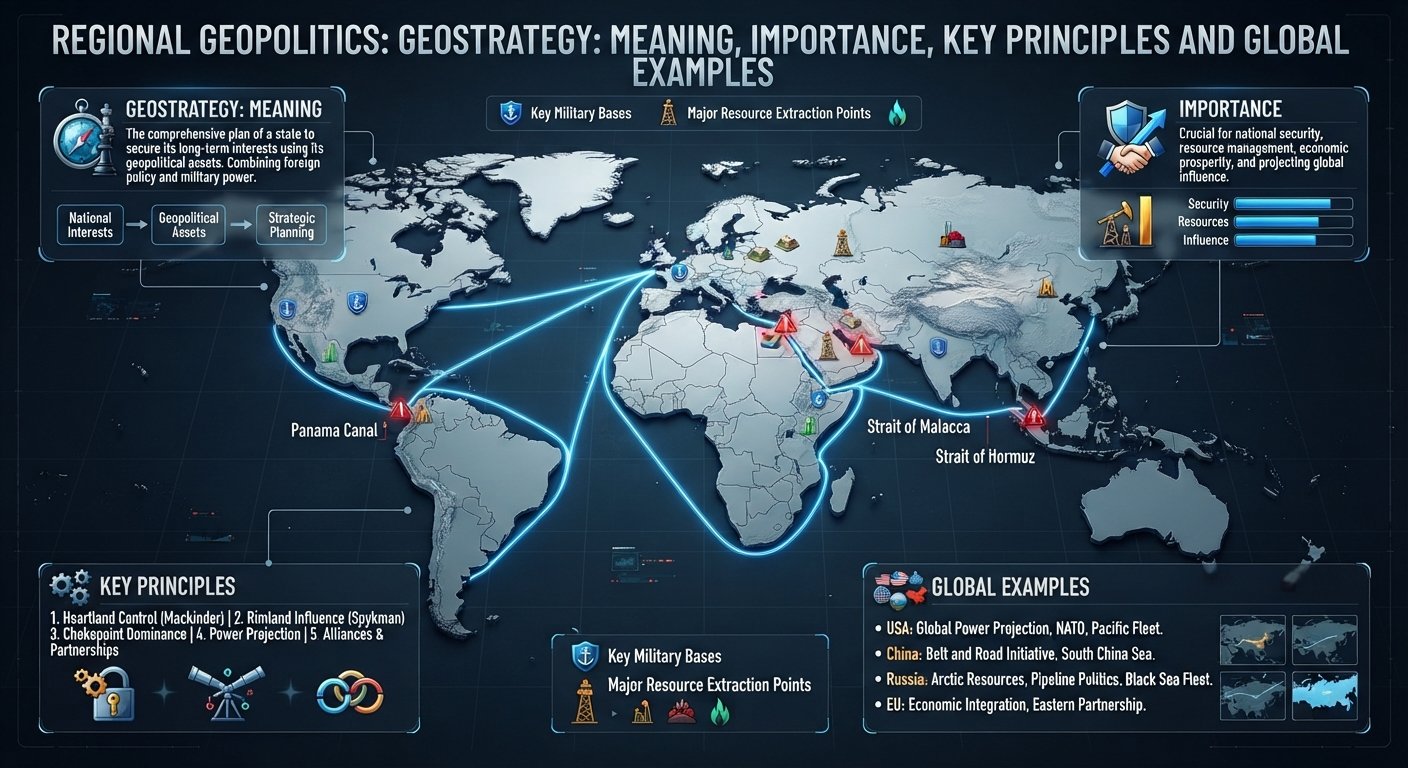
Geostrategy is the study and practice of using geography, power, resources, alliances, technology, and strategic planning to achieve political, economic, and security objectives. It sits at the intersection of geography, geopolitics, foreign policy, national security, economics, and military strategy.
In international affairs, geography does not determine a country’s choices by itself. Mountains, oceans, borders, ports, resources, population centers, trade routes, and strategic chokepoints create opportunities and constraints that governments must consider when deciding where and how to project power.
The concept is especially important in an era of renewed strategic competition. Maritime chokepoints, Arctic routes, critical minerals, energy corridors, semiconductor supply chains, military alliances, space infrastructure, and digital networks have all become part of contemporary strategic calculations. NATO, for example, describes the Arctic as both a gateway to the North Atlantic and an area of increasing strategic competition. (NATO)
Understanding geostrategy therefore requires more than looking at maps. It means asking who wants what, where their interests are located, what resources they possess, what constraints geography creates, and how they intend to translate those advantages into political influence.
What Is Geostrategy?
Geostrategy can be understood as the use of strategic planning to pursue national or organizational objectives while taking geographical realities into account.
Merriam-Webster defines geostrategy as a branch of geopolitics dealing with strategy, the combination of geopolitical and strategic factors in a geographic region, and the use of government strategy based on geopolitics. (Merriam-Webster)
A useful way to simplify the concept is:
Geopolitics helps explain how geography influences power and international politics; geostrategy focuses on how actors use that understanding to pursue strategic objectives.
Geostrategy therefore connects geography with action.
A country may possess a favorable geographic position, but that advantage becomes strategically meaningful only when it can be converted into influence, security, economic leverage, deterrence, connectivity, or military capability.
For example, a state located near an important maritime passage may seek to:
- protect the passage;
- establish naval capabilities nearby;
- develop ports and logistics infrastructure;
- form partnerships with neighboring states;
- protect energy and trade routes;
- use its location to increase diplomatic leverage.
This is geostrategic thinking.
Geostrategy vs. Geopolitics
The two concepts are closely related but are not identical.
Geopolitics primarily examines the relationship between geography and political power. It asks why particular locations, borders, resources, populations, and physical environments matter politically.
Geostrategy goes a step further by examining how governments and other actors translate geographic realities into strategic policies.
| Concept | Main Question |
|---|---|
| Geography | Where are things located? |
| Geopolitics | How does geography affect political power? |
| Strategy | How can available resources achieve objectives? |
| Geostrategy | How can geographic advantages and constraints be incorporated into strategy? |
| Foreign policy | How does a state pursue its external interests? |
The distinction is not absolute. Scholars and governments sometimes use these terms differently.
Why Is Geostrategy Important?
Geostrategy matters because geography creates enduring advantages and constraints even when technology and political systems change.
A country’s location can affect:
- access to oceans;
- vulnerability to invasion;
- proximity to competitors;
- access to markets;
- energy security;
- military mobility;
- transportation networks;
- diplomatic relationships;
- resource availability;
- strategic depth.
Technology can reduce some geographic constraints, but it rarely eliminates geography altogether.
Modern communications, long-range missiles, satellites, cyber capabilities, aircraft, autonomous systems, and advanced logistics allow states to operate across enormous distances. Yet those capabilities still depend on physical infrastructure, supply chains, bases, ports, airfields, cables, satellites, energy systems, and access to strategic regions.
This is why geography continues to matter in twenty-first-century international relations.
Geography as an Opportunity
Geography can provide strategic advantages.
A country with access to major oceans may develop strong maritime trade and naval capabilities. A country located between major markets may become a transportation hub. A state controlling a strategically important passage can acquire political and economic significance.
Geography as a Constraint
Geography can also create vulnerabilities.
Landlocked states may depend on neighboring countries for access to international markets. States surrounded by powerful neighbors may face difficult security calculations. Countries dependent on imported energy or vulnerable trade routes may need extensive diplomatic partnerships.
Thus, geostrategy is partly about managing geographic constraints while exploiting geographic opportunities.
Historical Development of Geostrategy
The relationship between geography and strategy is much older than the modern term geostrategy.
Ancient empires considered rivers, mountain passes, ports, fertile plains, and trade routes when expanding or defending their territories.
Modern geostrategic thinking developed more systematically alongside military geography, naval power, industrialization, imperial competition, and the emergence of modern nation-states.
Academic literature traces early uses of the term to nineteenth-century strategic thought, while its modern strategic vocabulary became increasingly influential during the twentieth century. (Perlego)
Classical Strategic Geography
Several historical thinkers strongly influenced modern debates.
Alfred Thayer Mahan emphasized maritime power and the importance of naval strength, commercial shipping, ports, and sea lanes.
Halford Mackinder emphasized the strategic importance of Eurasia and continental power in his famous Heartland thesis.
Nicholas Spykman developed the Rimland concept, emphasizing the importance of the coastal regions surrounding Eurasia.
These theories should not be treated as timeless laws. They emerged under particular technological and political conditions. Nevertheless, they continue to influence discussions about maritime power, Eurasia, strategic depth, and global competition.
The Cold War
During the Cold War, geostrategy became central to the competition between the United States and Soviet Union.
The rivalry involved:
- military alliances;
- nuclear deterrence;
- naval deployments;
- overseas bases;
- strategic air power;
- control of transportation routes;
- ideological competition;
- economic influence;
- competition for influence in Europe, Asia, Africa, Latin America, and the Middle East.
The geographic position of Europe, the North Atlantic, the Mediterranean, the Middle East, and East Asia shaped military planning and alliance structures.
Post-Cold War Geostrategy
After the Soviet Union collapsed, many analysts initially expected a less strategically competitive international system.
However, subsequent developments—including NATO expansion, Russia-West tensions, China’s economic and military rise, conflicts in the Middle East, renewed competition over maritime routes, and technological rivalry—returned geostrategy to the center of international affairs.
NATO’s 2022 Strategic Concept, for example, identifies deterrence and defence, crisis prevention and management, and cooperative security as its three core tasks while describing a changing security environment marked by renewed strategic competition. (NATO)
The Core Elements of Geostrategy


Geostrategy is multidimensional. Geography is the foundation, but strategic outcomes depend on much more than location.
Geography and Terrain
Physical geography remains fundamental.
Important geographic features include:
- mountains;
- deserts;
- rivers;
- plains;
- islands;
- coastlines;
- oceans;
- straits;
- canals;
- borderlands.
Terrain can affect military mobility, transportation costs, defensive positions, infrastructure development, and economic connectivity.
Strategic Location
Some locations have greater strategic value than others.
A territory becomes particularly important when it sits near:
- major shipping routes;
- energy corridors;
- military approaches;
- valuable resources;
- major population centers;
- contested borders;
- transportation networks.
Location can therefore provide influence disproportionate to a country’s size.
Chokepoints
A strategic chokepoint is a narrow passage through which significant flows of trade, energy, military movement, or communications must pass.
Important examples include:
- Strait of Hormuz;
- Strait of Malacca;
- Bab el-Mandeb;
- Suez Canal;
- Panama Canal;
- Turkish Straits.
The strategic importance of these locations becomes clear when disruptions occur.
UN Trade and Development has documented how disruptions involving the Suez and Panama canals and Red Sea routes can increase shipping distances, costs, congestion, and supply-chain vulnerabilities. (UNCTAD)
The U.S. Energy Information Administration also identifies major maritime chokepoints as critical to global energy security because large volumes of petroleum and other energy commodities pass through them.
Resources
Natural resources can strongly influence strategic planning.
These include:
- oil;
- natural gas;
- coal;
- uranium;
- freshwater;
- food-producing land;
- critical minerals;
- fisheries.
Resource-rich territories may become strategically important to both producers and consumers.
Economic Power
Modern geostrategy cannot be separated from economics.
States can pursue strategic objectives through:
- trade agreements;
- sanctions;
- investment;
- infrastructure financing;
- development assistance;
- export controls;
- supply-chain diversification;
- industrial policy.
Economic relationships can therefore create strategic dependence—or reduce it.
Military Power
Military capabilities remain an important component of geostrategy.
Relevant factors include:
- armed forces;
- naval power;
- air power;
- missile capabilities;
- nuclear deterrence;
- military bases;
- logistics;
- intelligence;
- space capabilities;
- cyber capabilities.
However, military power is only one instrument of geostrategy. A state can pursue strategic influence without deploying military force.
Alliances and Partnerships
A geographically vulnerable state can compensate for some disadvantages through alliances.
Military alliances can provide:
- collective defence;
- intelligence sharing;
- military interoperability;
- logistical access;
- deterrence;
- political support.
NATO represents one prominent example of an alliance whose strategic planning is shaped by geography and changing security conditions. (NATO)
Technology
Technology is changing the meaning of strategic geography.
Satellites can monitor remote regions. Long-range weapons can alter military calculations. Cyber operations can affect infrastructure without physically crossing borders. Artificial intelligence can improve intelligence analysis and decision-making.
Yet technology does not eliminate geography.
A satellite still operates in space. A data center requires physical infrastructure. Undersea cables run across seabeds. Semiconductor manufacturing requires specialized industrial ecosystems.
The result is a hybrid geostrategy combining physical and technological geography.
How Does Geostrategy Work?
Geostrategy links objectives, geography, resources, capabilities, and action.
A simplified model is:
Geographic position → strategic interests → objectives → capabilities → policies → outcomes
For example, imagine a country located near a major maritime trade route.
Its government may identify the route as strategically important because it supports national trade and energy imports.
It may then:
- develop port infrastructure;
- strengthen maritime surveillance;
- expand naval capabilities;
- establish diplomatic partnerships;
- protect shipping;
- diversify alternative trade routes.
The strategy is not simply about controlling geography. It is about using available geographic conditions to improve national security and economic resilience.
Major Forms of Geostrategy
Maritime Geostrategy
Maritime geostrategy focuses on oceans, ports, naval forces, sea lanes, islands, and chokepoints.
It is particularly important because maritime transport remains central to global commerce. UNCTAD reported in 2025 that shipping carries more than 80% of world trade by volume and that geopolitical tensions were reshaping maritime routes. (UNCTAD)
Countries therefore compete for:
- naval access;
- overseas logistics;
- port facilities;
- maritime surveillance;
- secure sea lanes;
- island positions.
Continental Geostrategy
Continental geostrategy focuses on land power, borders, transportation corridors, strategic depth, and control of major land regions.
Eurasia has historically received particular attention because it connects Europe, the Middle East, Russia, Central Asia, South Asia, and East Asia.
Energy Geostrategy
Energy supplies influence foreign policy because oil and gas require infrastructure and transportation networks.
Pipelines, LNG terminals, ports, refineries, electricity grids, and energy-producing regions can all acquire strategic importance.
Energy diversification is consequently both an economic policy and a geostrategic objective.
Economic and Geoeconomic Strategy
States increasingly use economic instruments for strategic purposes.
These may include:
- tariffs;
- sanctions;
- export controls;
- investment restrictions;
- industrial subsidies;
- technology controls;
- infrastructure partnerships;
- supply-chain diversification.
This has produced growing overlap between geostrategy and geoeconomics.
Arctic Geostrategy
The Arctic is becoming increasingly important because of its geographic position, natural resources, military significance, communications infrastructure, and potential shipping routes.
NATO currently describes the Arctic as a gateway to the North Atlantic and an area of increasing strategic competition, highlighting Russian military activity and growing Chinese interest in resources and sea lines of communication. (NATO)
Climate change adds another layer because changing ice conditions can alter access and operating environments.
Geostrategy and Major Powers
Geostrategy is particularly visible in the policies of major powers because they possess the economic, diplomatic, military, and technological capabilities to operate across multiple regions.
United States
U.S. geostrategy has historically been influenced by its favorable position between the Atlantic and Pacific oceans, continental scale, economic power, alliances, and extensive maritime capabilities.
Its alliances in Europe and the Indo-Pacific demonstrate how partnerships can extend strategic reach beyond national territory.
China
China’s geostrategic position combines a large continental population base, extensive coastline, major manufacturing capacity, proximity to important maritime routes, and access to Eurasian land corridors.
Infrastructure and connectivity projects associated with the Belt and Road framework illustrate how transportation and economic networks can have broader strategic significance. Chinese official documents identify multiple land and maritime corridors involving Eurasia, Southeast Asia, Africa, and other regions. (China Foreign Affairs Ministry)
Russia
Russia’s geography produces both advantages and constraints.
Its enormous landmass provides strategic depth and access to the Arctic and Eurasian interior, while its long borders and security concerns create significant defence requirements.
The Arctic is particularly important to Russia because of its northern coastline, military infrastructure, natural resources, and maritime interests.
India
India’s location at the center of the Indian Ocean gives it substantial geostrategic importance.
Its proximity to major sea lanes connecting the Middle East, Africa, and East Asia makes maritime security central to India’s strategic planning.
India’s continental borders also connect its strategy to South Asia, China, Central Asia, and the Himalayan region.
Geostrategy, Trade and Global Supply Chains
One of the clearest demonstrations of modern geostrategy is the relationship between geography and global supply chains.
A factory may be located thousands of kilometers from its customers, while its raw materials may come from several different countries. Those goods depend on ports, railways, roads, canals, shipping lanes, energy infrastructure, telecommunications, and financial systems.
This creates geographic vulnerabilities.
For example, UNCTAD reported that by May 2025 tonnage through the Suez Canal remained substantially below 2023 levels amid shipping disruptions, while rerouting increased transportation distances. (UNCTAD)
The strategic lesson is important:
Efficiency and resilience are sometimes competing objectives.
A company or country may prefer the cheapest route under normal conditions. But a strategically resilient system may deliberately maintain alternative suppliers, routes, ports, inventories, or production centers.
This is why supply-chain resilience has become a geostrategic issue.
Geostrategy and Technology
Twenty-first-century geostrategy increasingly extends beyond traditional territory.
Semiconductors
Advanced chips support artificial intelligence, telecommunications, military systems, automobiles, and industrial equipment.
Consequently, semiconductor manufacturing and supply chains have become strategically important.
Cybersecurity
Cyber infrastructure crosses borders but depends on physical networks.
Governments increasingly treat cyber resilience as part of national security.
Space
Satellites support:
- navigation;
- communications;
- weather forecasting;
- intelligence;
- military operations;
- financial systems.
Space is therefore another strategic domain.
Undersea Cables
Global digital connectivity depends heavily on physical submarine cables.
Their geographic routes, landing stations, vulnerability, and redundancy make them relevant to both economic security and national security.
Modern geostrategy is consequently no longer limited to land and sea. It increasingly involves land, maritime, air, space, cyber, and digital infrastructure simultaneously.
Why Geography Alone Does Not Determine Strategy
A common mistake is to assume that geography automatically determines foreign policy.
It does not.
Two countries can occupy similar geographic environments but pursue very different policies because they have different:
- political institutions;
- economic capabilities;
- historical experiences;
- leadership priorities;
- military capabilities;
- alliances;
- domestic political pressures;
- technological capabilities.
Geography creates constraints and opportunities, not predetermined outcomes.
This distinction is essential for serious geopolitical analysis.
Risks and Challenges of Geostrategic Competition
Geostrategic competition can generate several risks.
Security Dilemmas
One state’s effort to improve its security may make another state feel less secure.
This can trigger arms buildups and competing alliances.
Strategic Miscalculation
Governments may misunderstand an opponent’s intentions or capabilities.
Geographic proximity can make these errors particularly dangerous.
Economic Fragmentation
Strategic competition can produce:
- trade restrictions;
- sanctions;
- technology controls;
- duplicated supply chains;
- investment barriers.
These measures may increase resilience in some areas while raising costs elsewhere.
Conflict Over Strategic Locations
Territories containing ports, resources, transportation corridors, or military positions can become politically sensitive.
Infrastructure Vulnerability
Ports, pipelines, electricity grids, telecommunications networks, satellites, and undersea cables can become targets or pressure points during crises.
Future of Geostrategy
The future of geostrategy will probably be shaped by several overlapping trends.
Multipolar Competition
Power is becoming more distributed across multiple major and regional actors.
This creates a more complicated strategic environment than a simple two-power rivalry.
Maritime Competition
Oceans will remain central to trade, energy, military mobility, and communications.
Strategic chokepoints will therefore remain important.
Arctic Transformation
Changing environmental conditions could alter transportation, resource access, military operations, and regional competition.
Technology and Artificial Intelligence
AI may transform intelligence, military planning, logistics, surveillance, cyber operations, and economic competition.
Supply-Chain Resilience
Governments and businesses are likely to pay greater attention to geographic concentration and strategic dependencies.
Critical Minerals
The energy transition is increasing attention to minerals required for batteries, renewable technologies, electronics, and advanced manufacturing.
Climate Change
Climate change can alter the strategic value of regions through sea-level rise, water stress, changing agricultural conditions, extreme weather, and shifting Arctic access.
The result is likely to be a broader definition of geostrategy—one that connects security, economics, technology, environment, infrastructure, and geography.
How to Analyze Geostrategy
A practical geostrategic analysis can follow eight questions:
1. Who are the major actors?
Identify states, alliances, corporations, international organizations, and non-state actors.
2. What do they want?
Identify their stated objectives and distinguish them from analyst interpretations.
3. Where are their interests located?
Map territories, resources, trade routes, military positions, infrastructure, and strategic corridors.
4. Why does the geography matter?
Determine what geographic advantages or vulnerabilities influence strategic choices.
5. What capabilities are available?
Examine military, economic, diplomatic, technological, demographic, and infrastructural capabilities.
6. What constraints exist?
Consider domestic politics, economic costs, geography, alliances, international law, and resource limitations.
7. What are the likely consequences?
Analyze regional and global effects rather than focusing only on the immediate actors.
8. What could happen next?
Develop several plausible scenarios rather than predicting one inevitable outcome.
This framework helps distinguish geostrategic analysis from simple geopolitical commentary.
Frequently Asked Questions About Geostrategy
What is geostrategy in simple words?
Geostrategy is the practice of using geographic realities—such as location, borders, resources, trade routes, and strategic infrastructure—to achieve political, economic, and security objectives.
What is the difference between geopolitics and geostrategy?
Geopolitics examines how geography influences political power and international relations. Geostrategy focuses more directly on how actors use geographic conditions to pursue strategic objectives.
Why is geography important in geostrategy?
Geography influences access to resources, markets, oceans, transportation corridors, military approaches, and strategic locations. It creates opportunities and constraints for states.
Is geostrategy only about military power?
No. Modern geostrategy includes diplomacy, trade, investment, infrastructure, technology, energy, alliances, cyber capabilities, and economic security in addition to military power.
What are examples of geostrategic locations?
Examples include the Strait of Hormuz, Strait of Malacca, Suez Canal, Panama Canal, Bab el-Mandeb, the Arctic, and strategically important ports and transportation corridors.
Why are maritime chokepoints important?
Chokepoints concentrate trade and energy flows through relatively narrow routes. Disruption can force ships to take longer alternative routes, increasing costs and creating supply-chain problems. (UNCTAD)
How does technology affect geostrategy?
Technology expands the geographic reach of states and creates new strategic domains such as cyber and space. At the same time, technology depends on physical infrastructure, resources, manufacturing networks, and geographic locations.
Is geostrategy the same as foreign policy?
No. Foreign policy encompasses a state’s overall external relations and objectives. Geostrategy is one way of designing and implementing strategic policy by incorporating geographic factors.
Why is geostrategy important for businesses?
Businesses depend on stable trade routes, energy supplies, markets, infrastructure, technology, and supply chains. Geostrategic competition can therefore affect investment decisions, logistics, insurance, sourcing, and political risk.
Conclusion
Geostrategy explains how geography becomes part of strategic decision-making. It connects physical space with political objectives, military capabilities, economic interests, diplomatic relationships, technology, and national security.
Its importance has not disappeared in the age of globalization. Instead, globalization has created new forms of strategic interdependence. Maritime chokepoints, energy corridors, supply chains, ports, digital networks, satellites, critical minerals, and Arctic routes can all influence the distribution of power.
The most useful way to understand geostrategy is therefore not to assume that geography determines destiny. Geography establishes the opportunities, constraints, distances, vulnerabilities, and strategic positions within which governments and other actors make choices.
In an increasingly competitive international system, understanding those choices—and the geographic realities behind them—is essential for interpreting global affairs.